Map
Arturo Genre Path Map - complete itinerary
Presentation
The itinerary is named Arturo Genre path in memory of the linguist who was so fond of these places, he proposes to retrace ancient connecting routes between the Massello valley and the Maniglia side. In particular, the itinerary takes place on a circular route between a lower altitude level (1,013 m) and higher altitudes (1,743 m), connecting Massello with Maniglia (Perrero). The itinerary presents many historical, toponymic, environmental, cultural and anthropic aspects: from suggestive panoramic stretches to crossings of the undergrowth; from the almost imperceptible traces of human events of the past, to the mining sites of more recent history: and from the activities and lifestyles of the past, to the current active forms that are still found along the route. As a reason for completeness, the toponymy was highlighted with reference to the local Occitan dialect, respecting a linguistic culture that is still current but which has permeated over time the places where there was human presence. The Occitan language preserved in the valleys of western Piedmont is native to the language of Oc, whose first documents date back to the 10th century. Over the last forty years there has been constant and precious work by many to create the conditions for an awareness of the dignity of the Occitan language. An expression of this research is also the "Dizionario del Dialetto Occitano della Val Germanasca" edited by Teofilo G. Pons and Arturo Genre (Ed. 1973 and 1997). The spelling of the itinerary signage is taken from the latest edition.
Arturo Genre
Born in Marseille in 1937, he graduated in Modern Foreign Languages and Literatures at the Faculty of Letters and Philosophy of the University of Turin, where he taught experimental phonetics. He worked for twenty-five years at the Italian Linguistic Atlas, as editor, editor-in-chief and then director until 1990 and was scientific director of the Toponymic Atlas of Montano Piedmont. After the thesis dedicated to the phonology of Prali's speech, his interest in the Occitan language of Val Germanasca continued through the analysis, in particular, of the phenomena that most characterized it: diphthongization, vowel and consonantal quantity, nasality. He published the text of the Gospel of Mark in the Occitan variety of Rodoretto. He has also dealt, in various works, with the speech and origins of the Calabro-Waldensians. He published the Dictionary of the Occitan dialect of Val Germanasca in 1997. He died in Turin in the same year
Road access
From Pinerolo follow the state road n. 23 from the Sestriere hill up to Perosa Argentina. After crossing the town centre, turn left and take the Valle Germanasca provincial road (road signs for Pomaretto, Perrero, Prali). About a km. After Perrero you reach the bridge that crosses the Germanasca di Massello stream. To reach the start of the itinerary from Maniglia, take the road that goes up on the right immediately before the bridge (road signs for San Martino, Bovile, Chiabrano and Maniglia). After passing the crossroads for San Martino and crossing Chiabrano and Baissa, reach the village of Serre di Maniglia where there is a notice board.
To reach the start of the itinerary from Massello, however, you need to cross the bridge and, immediately afterwards, turn right onto the provincial road for Salza and Massello. After about 5 km, you reach a small square in the locality "Lâ Laramuza”, where there is also a notice board there.
A further possibility is that of leaving the locality "Cairo” of Massello.
Implementation period
The southern exposure allows the basic route to be followed from spring to late autumn. With little snow it is possible to do the route even in winter, excluding the Bâ Jouann variant.
Current anthropic reality
The territory affected by the project reflects the typical situation of most mountain areas not reached by mass building and tourist speculation. It demonstrates the concern of the inhabitants for the conservation of the homes and for their maintenance, without, however, particular attention in recent years to criteria of continuity in the architecture and in the use of traditional materials (wood and stone). Today, however, there is greater sensitivity, including cultural sensitivity, for a recovery regulated according to aesthetic purposes of adaptation to the surrounding natural environment while respecting the original architectural line of the villages, with the use of typical materials. This concerns the villages reachable by motorized means, where however the depopulation is evident and people return only for the weekend or holidays.
The "miande", mentioned later among the historical testimonies of a way of life ever further back in time, located in locations generally reached only by mule tracks, have been largely forgotten and abandoned to themselves.
The depopulation occurred, as we know, due to the decreased profitability of mountain agriculture and the increase in economic possibilities further down the valley; Furthermore, work in the mines has gradually been reduced, first with the closure of the mines Vallone di Maniglia (1968) and after with the decline in work at Gianna di Prali, resulting in retirement of the elderly and an extreme reduction in new hires.
Some elderly people remain actual residents throughout the year (very few young people), some passionately dedicated to a residual agriculture of an ancient survival model (Doors of Massello), which uses the environment respecting it and maintaining its characteristic terracing.
Finally, among the human activities still present in our context, sheep farming in the mountain pastures of Trounchéo-Coulmian conducted in the summer months by a family of local origin, with many cattle and sheep and goats. Grazing takes place on the meadows of the aforementioned areas where mountain dwellers once practiced haymaking at high altitudes.
Naturalistic aspects
The geographic space between Handle e Solid it crosses different environments allowing you to make beautiful naturalistic observations.
From the point of view geological, the route winds along the connection between the two major tectonic units that make up the valleys of the Pinerolo area: the crystalline massif of Dora Maira (in the area of Handle up to the watershed of Solid) and the complex of lime schists and green stones (in the part that goes from the watershed up to Troncea and others Doors of Massello).
The area of Handle is located in a very fragmented horizon formed by quartzites, limestones, crystallines, ampholites, prasintes and talcoschists.
As regards the complex of limestone schists, it should be remembered that one of the lenses of green stones that emerge in the complex is the one that constitutes the tip of Raccias (2,205 m).
In terms of flora and fauna there are no notable particularities. Nonetheless, the route presents notable qualities from both a faunal and floristic point of view.
The flora: along the route you pass through different types of forest (where there are specimens of considerable size); at lower altitudes the splendid pine forest of Scots pine (Pinus silvestris) abound below rhododendrons (Rhododendron ferrugineum) e blueberry (Vaccinium myrtillus); this type of forest covers most of the route section of the "Bâ Jouann”, in which specimens of oak (Quercus petræa): from a pine forest, towards other slopes and higher altitudes, the forest gradually becomes a forest of beech (Fagus sylvatica) and from this it turns into larch forest (Larix decidua), above which the high altitude pastures begin.
In transition environments and abandoned crops we will find the hazelnut (Corylus avellana), the laburnum (Laburnum anagyroides), the ash (Fraxinus excelsior), the blackthorn (Prunus spinosa), the red elderberry (Sambucus racemosa).
Among herbaceous plants, the most widespread genera distributed among the various environments are the cranberry (vaccinum vitis idæa), le gentians (Gentiana – various species), i colchici (Colchium – various species), lo wild saffron (Crocus – various species), le violas (Purple – various species), gli anemones (Anemone – various species) and the pulsatille (Pulsatilla – various species), i buttercups (Ranunculus – various species), i dog teeth (Erythronium dens canis), the liver (Hepatica nobilis), the orchids (Orchis sambuchina) and many others.
To best enjoy the spectacle offered by the flowering, the ideal is to follow the itinerary in the June-July period. In the woods it is possible to observe different species of mushrooms, many of which are edible.
The fauna: “visible” animals are essentially ungulates; roe deer (Capreolus capreolus) e suede (Rupicapra rupicapra) can be observed along the entire route.
Chamois in particular is abundant, especially in the pine forest of the "Bâ Jouann" (a very wild area) and in the May-June period it is not difficult to observe mothers and young of the year moving on the rocky banks that separate Massello from Maniglia.
However, there are always traces and signs of presence of all the other animals, the encounter is due to luck or long stalking. The wild boar (Sus scrofa) whose traces are found almost everywhere, the dormouse (Glis glis) il wild mouse (Apodemus sylvaticus) lo squirrel (Sciurus vulgaris) whose meal remains are found mainly in pine forests and hazelnut groves. The corpses of the little ones shrew (Sorex – various species) and voles (Clethrionomys – various species) can sometimes be found on the trail.
From the facts, however, one can identify the presence of hare both common and variable (Lepus capensis or europæus and timidus); of fox (Vulpes vulpes), of some mustelids such as weasel (Martes faina) e weasel (Mustela nivalis) and del rate (Meles meles) recognizable by the latrines.
In high altitude pastures it is not uncommon to hear the whistle of the marmot (Marmota marmota).
It deserves a separate discussion wolf, a stable presence for more than a decade now and of which we often see traces of its passage, as well as the remains of mauled animals. A herd had taken up residence not far from La Frâcho and during the summer evenings it was possible to clearly hear their howls.
As regards the avifauna, there are numerous species present in the area and among all, only the most easily observable ones are mentioned: the jay (Garrulus glandarius), i peaks (Dendrocops – various species), le tits (Parus – various species), the cruises (Loxia curvirostra). It is not uncommon, although rare, the presence of black grouse (Lyrurus tetrix).
In the sky you can always see the raven (Corvus corax), the Alpine chough and coral chough (Pyrrocorax graculus and pyrrocorax), the kestrel (Falco tinniculus), but above all the most majestic buzzard (Buteo buteo) e eagle (Aquila chrysætos). Among the nocturnal birds of prey they should only be mentioned the owl (Strix aluco) and the owl (Athene noctua).
Larvae can be found in pools of stagnant water fire salamander (Salamandra salamandra) while in high altitude pastures the presence of the viviparous is suspected Lanza salamander (Lanzai salamander).
Among the reptiles is found the viper (Vipera aspis), dangerous for its venomous bite, but generally not aggressive, the green lizard (Lacerta viridis), the fragile one slow worm (Anguis fragilis) and the rat snake (Coluber viridiflarus).
As far as insects are concerned, the most easily found are certainly the red ant (Formica rufa) and lo dung beetle (Geotrupes stercorarius), which is found in large concentrations especially in the spring period. Under the stones or in the tall grass it will be easy to spot some carabids (Carabus – various species) without talking about the many species of butterflies.
The Arturo Genre path is identified as itinerary VS1: “LA FRACHO/BÂ JOUANN“
The route is marked with yellow-red marks placed along the direction of travel alternating with trail signs, always yellow-red with the symbol VS1 for the main itinerary e VS1a for the Bâ Jouann variant.
The wooden signs indicate the most interesting places and the toponymy of the villages or particular areas you pass through.
The area affected by the route is located in the upper Val Germanasca and includes the two sides of the watershed line that descends from the tip Raccias until Gardëtto and the provincial road.
To be followed in its entirety, the circular itinerary includes some main starting and arrival points: the Maniglia greenhouses, or the Caire/Ciaberso di Massello, or even the location Lâ Laramusa which is located along the provincial road nr. 170. Km 4.3 between Perrero e Solid.
The route takes place along paths, mule tracks, forest tracks and some stretches of carriage road. It presents no difficulty and can be done by anyone with a minimum amount of training in mountain walking. Only the stretch of the variant of Bâ Jouann it is reserved for more experienced hikers as the path goes past a rocky rampart and has some exposed sections towards the void. Furthermore, following the 2003 fire, during the winter the snow load caused some trees that were still burned but still standing to fall. The fact that it is not followed very regularly requires maximum attention not to lose sight of the frequent notches that trace the path.
For ease of analysis, the departure/arrival in the village of the is assumed Maniglia greenhouses, proceeding towards the higher altitudes until reaching the panoramic area of "La Fracho", and then descending into the territory of the Vallone di Solid and go back to Maniglia greenhouses.
The route
The beginning of the journey starting from Handle it is in the village dl Greenhouses ( Lou Sère – 1132 m.), place of origin of Arturo Genre.
After leaving the car in this location, continue for a hundred meters on a dirt road with a flat route until you reach the mule track on which the itinerary takes place. Turn right (sign Fracho) and go up for a short distance crossing the asphalt road that goes up from Greenhouses a Lorenzo e Saretto. After another short stretch of mule track you reach a dirt road.
Turn left and follow it for approx. one km. Just before the village Bocetto (Lou Boûchét – 1219 m.) leave the road and take the mule track that goes up on the right.
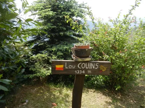
Continue until you reach the small village Lou Couins (1 hour – 1334 m.) where you find the road closed to traffic. Once you reach the houses, turn right and go back to the center of the town ( fountain).

Follow the mule track which, at the end of the houses, enters a forest of conifers and beech trees and, with a rather steep route, reaches the locality Malzet (Lou Malze) (1 hour – 1643 m.).
Crossing the coniferous and beech forest you can notice some lay-bys which testify to the existence of ancient charcoal burners (lâ chërbouniëra). Noticeboard
Just before arriving at the houses in the locality Malzet (Lou Malze) Noticeboard, you come across a water source. Houses like those of Malzet, located in rather extreme places in terms of altitude and distance from more liveable centres, were once born with a very specific purpose, referring to the predominantly agricultural life that was led in these mountain valleys: they were "lâ mianda", commonly called "miande" or "huts". This "mianda" in particular, until a few years ago was owned by a family from "Porte" of Massello who moved there with their cows only for the month of August.
Follow the mule track which, at the end of the houses, enters a forest of conifers and beech trees and, with a rather steep route, reaches the locality Malzet (Lou Malze) (1 hour – 1643 m.).
Crossing the coniferous and beech forest you can notice some lay-bys which testify to the existence of ancient charcoal burners (lâ chërbouniëra). Noticeboard
Just before arriving at the houses in the locality Malzet (Lou Malze) Noticeboard, you come across a water source. Houses like those of Malzet, located in rather extreme places in terms of altitude and distance from more liveable centres, were once born with a very specific purpose, referring to the predominantly agricultural life that was led in these mountain valleys: they were "lâ mianda", commonly called "miande" or "huts". This "mianda" in particular, until a few years ago was owned by a family from "Porte" of Massello who moved there with their cows only for the month of August.
From “Lou Malze” the path continues uphill and crosses a flat place now covered in grass, also the remnant of an ancient charcoal pit.
In a short time (20') you exit the Scots pine forest and reach the highest altitude of the itinerary: "Fracho” (1743 m.), corresponding to the watershed line that roughly divides the territory of Maniglia (Perrero) from the municipality of Massello. Here pines and larches, now sparse and smaller in size, give way to extensive spaces of prairie, which characterize the high altitude pastures in a very suggestive way. Even now in the summer season they constitute mountain pasture territory and are grazed by cows, sheep and goats.

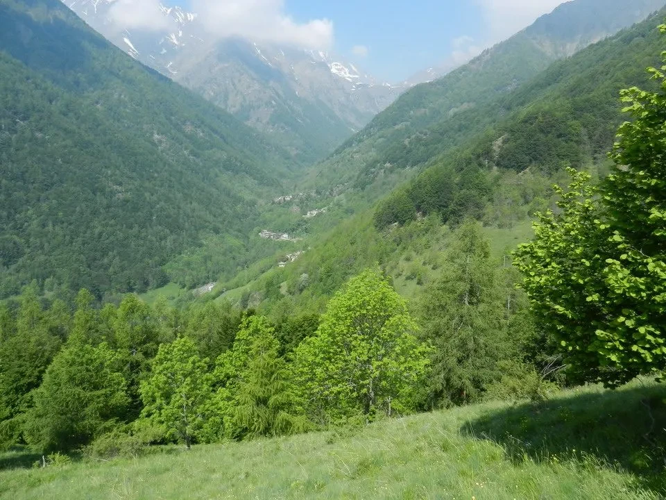
A few meters away, always in the area of Fracho, from an extreme point of the watershed ridge you can observe in an even more suggestive way a fascinating rather vast panorama which from east to west allows you to observe the valley floor and many places in the Municipality of Perrero: Riclaretto, Faetto, Bessé then on the orographic right of the Germanasca torrent San Martino, Maniglia, the Muret alp on the left; in front, the ridge of “Bô la Vaccho", an extensive forest of pines, firs and larches, which houses some caves including the "Tuno dî Vodouà” (la cave of the Waldensians) which also hosted some groups of partisans during the Second World War. To the right of Bô la Vaccho, the Colle delle Fontane and the valley of Salza and, in the background, the mountains of Rododoret e Prali (White Rock, etc.). Towards the west the entire Massello valley with the Bric Ghinivert (3037 m.), Mt Pelvis (2803 m.) and the waterfall of Pis.
As previously mentioned, the buttress on which it is located Fracho outlines, from the overlying tip of the Raccias (altitude 2205), the geographical limit between Maniglia and Massello (the administrative one follows the gully ofBâ dâ Pons”) and along the underlying forest of “Bo Lonc” descends to the Germanasca di Massello.
LH’ËNTRANCHAMËNT (The trenches)
Continuing the journey, in a few minutes you find yourself in the vicinity of the miande of Pic: an ancient route, “The way of Savouiart”, from the left it cuts across our path and continues towards the Coulmian clearings up to the buttress of the Valoun (alp of Balmetta); in the past it was maintained and used for the transport of hay and wood by sled, hence the more recent name of "I go to the lèo” (sled route). Some water sources emerge in this area. The miande of Pic they are abandoned but still in fairly good condition
In short from here you reach the Pra la Granjo (1700 m.) another plateau at the base of the vast Alpe di Coulmian, where mountain violets, anemones and gentianlings bloom in spring.
At this point the forest track begins which descends into the larch and beech forest of the "Vachie”. We arrive (25') at miande of Troncea (The Trounchéo – 1609 m.), current summer residence of the margaro (lou bërgìe) of the alp of Coulmian. Noticeboard
LH'ALP D'MASÈEL (The mountain pastures of Massello)
From Troncea you go down to the miande del Praiet (Lou Praiet – 1489 m.) passing through “The Trounchéo d'aval” (group of old disused miande). Panorama

The Praiet it is a picturesque and simple complex of huts on the ledge of the slope that the route follows downhill towards Massello valley floor
From Praiet, following the signs, take the mule track on the left which, after crossing a small bridge over a stream ("Lou Riou”), enters the woods of “Bô lâ Cross” until you reach the viewpoint of “ Bric d'lâ Porta ”, where a panoramic view of the valley opens onto various villages.
The stretch is short (35') to reach the beautiful village of Doors (The Door – 1386 m.), tidy and partially still cultivated although headed for a slow decline. Some elderly people still live here, even in winter, dedicated to a bit of agriculture who have well maintained the surrounding rural environment in all these years, where the characteristic terracing, an ancient system for stabilizing the soil.
From Doors proceed along the asphalt road for about 1 km until the detour indicated for the "Gardetta” (VS1 sign) and take a path again which after a short climb and then about fifty meters on level ground (20') reaches the miando di Gardetta (La Gardëtto – 1343 m.). Noticeboard. The tub for collecting water is characteristic, chiseled entirely into the rock
The path from the hut de La Gardëtto, descends (10') along hairpin bends in the woods to the village of Ciaberso (Lou Chabers – 1215 m.).
JUST BEFORE REACHING THE CAR ROAD, YOU CAN EVENTUALLY TURN LEFT TO TAKE THE RETURN TO SERRE DI MANIGLIA THROUGH THE VARIANT VS1A OF THE PATH OF “BÂ JOUANN”. THIS VARIANT, DUE TO ITS GEOMORPHOLOGICAL CHARACTERISTICS, IS SUITABLE FOR THOSE WHO HAVE SOME EXPERIENCE OF IMPOSSIBLE PLACES. FOR THE RELATED DESCRIPTION SEE FURTHER.
The Ciaberso it is a beautiful village that maintains the typical architectural features of the place, uninhabited in winter but summer home to some valley dwellers who have emigrated to the valley. In the Beckwith school building, it houses a permanent exhibition of panels reporting cultural and historical information on the ancient mills of the valley.
At this point the VS1 itinerary coincides for a stretch with the route called "The wheel and the water" which leads to the various mills of Massello.
A little further on you reach the Cairo (Lou Caire), headquarters of Catholic Church (The gleizo catolio).
PLACES OF WORSHIP IN MASSELLO
Around the Cairo it is possible to observe the names of various plants on small signs, an initiative carried out by the parish priest and some friends.
This place offers a beautiful panorama of the valley to the west Pis with the waterfall of the same name.
Below the Catholic Church you go down the mule track that leads (30') to "Lâ Laramuza”. The last stretch of this coincides with the ancient road at the bottom of the valley which connected Massello with Perrero until the beginning of the 1930s.
The solitary building in a state of abandonment that you encounter on this stretch was the morgue. From this area you can see the village of in front Campolasalza.
Just before reaching the bottom of the descent you can notice a low wall upstream, where travelers who often carried heavy loads of supplies etc. on their shoulders stopped and rested. For this reason the place was named "The Paouzo”, that is stop.
The intersection with the asphalted provincial road is in the aforementioned location Lâ Laramuza. Turn left and continue for about a kilometre, up to the "Bâ dâ Pons” (1013 m.), which marks the border between the municipalities of Perrero and Massello.
It is a suggestive place due to the harshness of the two opposing sides and the evergreen vegetation.
Before taking the mule track on the left that leads to the Vallone di Maniglia, it is worth observing to the right of the stream against a rock wall, the remains of the walls of an old water canalization that reached the village of Besse (Lou Bësé), further downstream in front of Maniglia.
For fans of legends, we recommend reading “Il canale del Bësé” on “Legends and popular traditions of the Waldensian valleys” by Arturo Genre and Oriana Bert. (Claudiana, 1977).
LOU BIÂL DÂ DIAOU (The Devil's Channel)
The mule track that goes up on the left of the provincial road into a shady pine forest leads to a view of the buildings of the Vallone di Maniglia (Lou Valoun – 1067 m.) and in the talc mining site abandoned at the end of the 1960s (30').
LÂ GALARÌA DÂ VALOUN DË MANËLHO (The talc mines of the Vallone di Maniglia)
Once in sight of the mine buildings, do not cross the iron bridge over the Rio Molotta, but follow the mule track that enters the valley along the support wall of the Décauville railway serving the mine. You then cross, further upstream, the Rio Molotta and go up with some hairpin bends on the opposite side until you reach the meadows and clearings above. From here, with an almost flat route you reach (30') the Maniglia greenhouses (Lou Sère – 1132 m.).
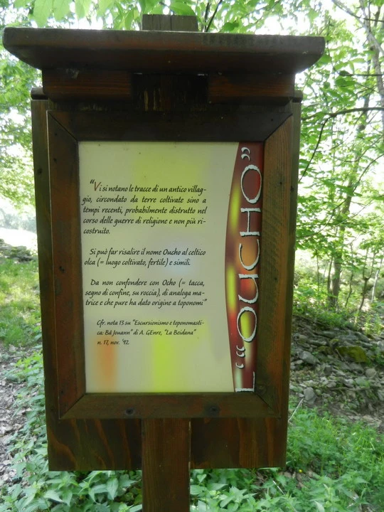
Along this stretch you can observe the remains of an ancient human settlement, the "Oucho", dating back to 1600.
The “VS1a” variant of BÂ JOUANN (alternative to the VS1 circular itinerary)
Captivating but difficult itinerary, at least for those seeking urban or geologically rural recreation; itinerary of other times, of times in which the human and sheep and goat species walked along the same steps, shared, moreover, from the scarce surviving game to a hunting harvest motivated by the primary need for a diet providing a sufficient protein contribution, which could not be drawn from the slaughter of a sufficient number of domestic animals.
An itinerary barely touched by confused imprints of the past, of which human memory and the written documents themselves bear just a few imprecise clues:
“it crosses a wild, stony territory for the most part, with frequent outcropping rocky spurs and cliffs, in some places tens of meters high, which abruptly interrupt the forest cover and offer, almost continuously up to the top of the mountain, serious obstacles to crossing” (A.GENRE)
This is the path of Bâ Jouann.
Its route follows the locations precisely identified by Arturo Genre, after careful research favored only recently by the renewed presence of wild boars which contributed to maintaining the route with their passage:
“Starting from Maniglia, starting from the Serre village (Lou Sère), the route passes through the meadows of Sannho, and of Rouét, then Lî Chënalh, Lou Bari d'l'Eichalìe, the Bëséo, Lou Moourèou, L'Oucho, L'Adreikt, Lou Preinas, the stones of Balmaso, the ruins of Pazeirëtta, the ledge of Bâ Jouann…
Further on, after a second passage carved into the rock, they begin Lâ Platta d’ Masèel, the clearings of Massello..."
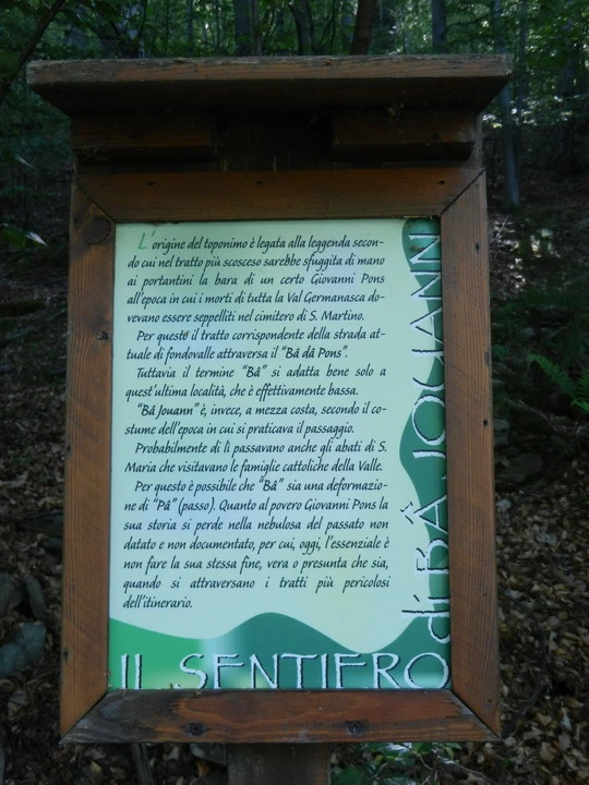
The origin of the toponym is linked to the legend according to which the coffin of a certain man slipped out of the hands of the bearers on the steepest stretch. Giovanni Pons at the time when the dead from all over the Germanasca Valley had to be buried in the cemetery of St. Martin. For this reason, the corresponding stretch of the current road on the valley floor through theBâ dâ PonsHowever, the term Bâ it adapts well only to the latter location, which is actually low. “Bâ Jouann"is, however, halfway up the hill, according to the custom of the time in which the passage was practiced. The abbots of S. Maria who visited the Catholic families of the Valley probably also passed through there.
For this reason it is possible that “Bâ” is a deformation of “Pâ” (Step). As for poor Giovanni Pons, his story is lost in the nebula of the undated and undocumented past, so, today, the essential thing is not to end up like him, whether real or presumed, when crossing the most dangerous sections of the itinerary.
Description of the VS1a route
The alternative route of Bâ Jouann is indicated at Handle in the area of Walloon and others Solid just above the Ciaberso.
Considering the route starting from the Ciaberso meadows, you reach the ridge quite quickly Bo Lonc, where the Vallone di is left behind Solid.
The landscape immediately takes on the impervious characteristics of this route.
Shortly after, on the left you can glimpse the remains of small children between the rock walls fields (the champ) cultivated in the past and now invaded by wild vegetation (brambles, wild cherry trees), recognizable by the typical low walls retaining the land.
In a short time you reach the area of stone quarry for roofing (La carìëro) by Lâ Laramuza. Noticeboard. A deviation to the right downwards indicates the very short distance to travel to reach the site.

The itinerary continues in a very suggestive way up to ledge of Bâ Jouann, where there is an unusual view of the Handle and on the valley of Perrero. Noticeboard
Crossed the gully that acts as the border between Handle e Solid, you reach the ruins of Lâ Pazeiretta, testimony of an ancient desperate search for pieces of cultivable land in times of difficult life, war and religious persecution; now an expression of a way of living and working characteristic of a not so distant past (up to around forty years ago) which today surround plants and brushwood in total abandonment.
The path, remaining approximately at the same altitude level, crosses an area rich in vegetation and dotted with numerous rocks with ravines (The Balmâso) used in the past and also during the partisan struggle as places of shelter and hiding place. In twenty minutes you reach the area of Vallone di Maniglia; before descending briefly into the gully of Rio Molotta, you can see the remains of the explosives storage used for advancements in talc tunnels. Crossed the Rio, turns to the right and immediately left in the direction Greenhouses. Along this last route you can still see traces of an ancient village: the Oucho.
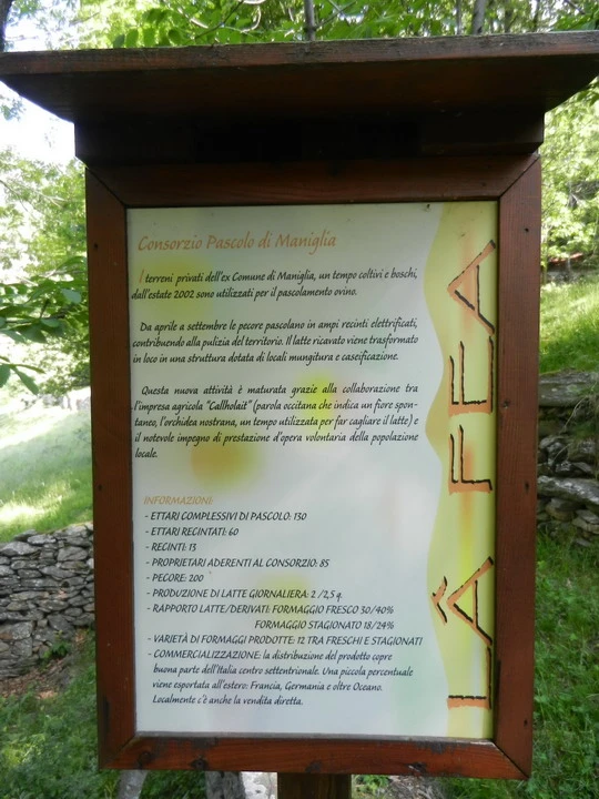
It is located in the area Maniglia Pasture Consortium, established to allow sheep to graze and to help keep the mountain context clean




Itinerary